Saturday, March 20, 2021
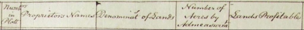
Griffith's Valuation; Understanding the Details
Griffith's Valuation was completed in County Kilkenny by July 1853 and in County Meath by July 1855. In lieu of a census, this is the most accurate information we can get about our Irish Ancestors just before they immigrated to the United States.
I understood a lot more about the Valuation after I read this article; "Is there more in Griffith's Valuation than just names?" You might want to read it yourself, but I have put some notes on the article below.
http://www.leitrim-roscommon.com/GRIFFITH/Griffiths.PDF
Griffith's Valuation is divided by the civil parish or administrative area (not the catholic church parish) and the townland- a small group of farms.
Relatives
Overall, we learn more about our ancestor's possible relatives in their own townland and adjacent townlands. Most people walked from place to place, so close relatives were often within a walkable distance (although people walked much longer distances in those days than most of us do now!)
Spouses
Spouses, also, were generally met and courted within walking distance, and it could be assumed that they likely lived within the same Roman Catholic parish, where the young people would see each other at church on Sunday.
Neighbors
Within each townland, the names within the valuation were listed in the order valuated, not necessarily the order of the adjacent farms. So- it is necessary to look at the maps to see who lived next to each other. (Still, townlands are generally so small that most people within them were close neighbors.)
Farm/Economic Status-
"Large Farmers" held more than 30 acres.
"Small farmers" held 5-30 acres. "Cottiers" or "laborers" held less than 5 acres.
Leases did not expire at the end of a year; they went on indefinitely unless the tenant chose to move elsewhere or the landlord took the tenant to court.
It was not unusual for a farmer to subdivide a holding to ensure the economic success of all. The names of the subdivided tenants are enclosed in parentheses. This was often done with relatives; sons, brothers, or son-in-laws. So if there is a different name within the parenthesis, it would be wise to check this person out as a possible marriage connection; perhaps a son in law or brother in law. During and after the famine, things changed. Many leases were limited to one year; at which point the tenant could be evicted if rents were not paid.
Homes and farm structures
The term "house" implies a dwelling place. There are different classes of houses which are taxed at different rates, based on the materials they are built with and their condition. The term "office" includes all of the outbuildings on the farm; sheds, barns, etc. This would include cow barns, piggeries, storage sheds, etc.
(add on- details from Griffiths on house ratings)
Maps
One of the most exciting elements of Griffith's Valuation is the inclusion of maps which show the exact land plot that our ancestors lived on. This can be compared to Google Maps to show where to find that land today.
You can explore Griffith's Valuation here!
http://griffiths.askaboutireland.ie/gv4/single_layer/place_name_search.pdf
http://www.askaboutireland.ie/griffith-valuation/
More information on the valuation here:
https://www.irish-genealogy-toolkit.com/Griffiths-Valuation.html
Our Allens in Laracor Parish, Meath (Laracor is the civil parish name- these Allens lived in the Summerhill Catholic Parish)
http://www.askaboutireland.ie/griffith-valuation/index.xml?action=doNameSearch&Submit.x=53&Submit.y=11&Submit=Submit&familyname=Allen&firstname=First+Name&baronyname=&countyname=MEATH&unionname=&parishname=LARACOR
Tuesday, March 16, 2021
History: Summerhill attacked during the Irish Confederation Wars- The Historic Battle of Dungan's Hill
We have to wonder if our ancestors were at Umberstown and Dangan in the 1600's. We know they were certainly there by the 1700's, so it is very likely. If so, they witnessed, and perhaps took part in, a bloody battle of epic proportions and its terrible aftermath.
In the 1600's there was a fine house and old castle in Knock (now Summerhill,) a fine stone house in Dangan with a bridge and mill, and a few cabins in Umberstown and other townlands. There were small castles in the surrounding townlands of Readstown, Little Freffans, Adamstown, and Laracor.

If you visit Summerhill, you will see this ancient stone pedestal on the village green It is the cross of Peter Lynch of Knock, who had been associated with the Irish Catholic rebellion of "Silken Thomas" (a Kinsella) in 1535. By 1609 there was a new castle on the land and the 1640 survey showed Garrett Lynch of Knock owning 590 acres, with two castles, a mill, an old chapel, and many cottages.

But in 1642, while Gerald/Garrett was away, the castle at Lynche's Knock was attacked by the forces of the Protestant Irish Royal Army under James Butler, Earl of Ormonde. All of the male defenders of the castle were executed. This was one bloody scene only 3 miles from our ancestors' cottages at Dangan. But a far worse battle was yet to come.
 James Butler, Earl of Ormonde
The Irish Confederation Wars (Eleven Years' War) 1641-1653
From 1642-1649, the Irish Catholic Confederation, based in Kilkenny, ruled 2/3 of Ireland. It had been formed by Catholic nobles, clergy, and military leaders after the Irish Rebellion of 1641, which sought to regain Irish Catholic rights. It held allegiance to the Catholic king of England-King Charles I.
The Irish Confederation Wars (Eleven Years War) lasted from 1641-1653. The Irish Catholic Confederation allied with English and Scottish Royalists against the English Parliamentarians. Small bands of civilians were raised by local lords to attack the opposing side.
During this horrific war over 25,000 Irish were killed on the battlefield, and over 200,000 civilians died from famine and disease, with 12,000 being transported to the West Indies by 1660.
In 1645 King Charles I was defeated during the English Civil War, with Parliamentarians taking power. In June 1647, James Butler, The Marquis of Ormond, who had been loyal to Charles, agreed to surrender Dublin to the Parliamentarian army under Col. Michael Jones.
The Battle of Dangan (Dungan) Hill

At first, I thought this referred to Dangan. Luckily I was off by a few miles. The Down Survey refers to a place called Dunganstown, with a large bog, which is just south of Summerhill. Still, these armies of thousands of men would have marched very close to our ancestors cottages as they passed down the main road from Trim and the horrible battle took place just a few miles from their homes. If they were indeed living there at the time, the battle itself and the aftermath of that battle, would have had a terrible effect on their lives. The map shows the proximity of the battle to the townlands of our ancestors- Umberstown and Dangan (bottom left.) Dungan hill and bog, the site of the horrific battle, was only a few miles away. (Map is not aligned north/south.)

The Down Survey describes the battle this way:

On Sunday, August 8, 1647, near Knock (later Summerhill) and on Dungan Hill, there was a great battle between the the Irish Confederates and the English Parliamentarians. The Irish Confederates were led by General Thomas Preston, who were planning to march on Dublin, which was held by the Parliamentarians. The Irish Confederate army consisted of about 4,000 foot soldiers pikes and heavy muskets, and a small cavalry of about 800 horses. They had been attempting a siege of Trim, but when the Parliamentarian force left Dublin, Preston decided to strike Dublin.
The Parliamentarian force, commanded by Colonel Michael Jones, had about 5,000 foot soldiers, a 1500 horse cavalry, and artillery. He caught Preston about ten miles south of Trim at Dangan. While the Irish cavalry waited on Dangan Hill, the Irish foot soldiers forces were hidden in a field of tall wheat preparing for a surprise attack, but this strategy made it hard for them to see anything. The Irish cavalry was then caught on the road by the English.
The English won the battle, slaying nearly over 3,000 Irishmen, and taking over 900 prisoners, including surviving leaders. Three of Garrett Lynch's sons died in the battle. According to Irish accounts, the troops were slaughtered even after attempting a surrender. The English, too, had heavy losses of over 2000 men. Preston, himself, escaped through the bogs with about 2000 men. He requested a burial of the dead, but received no reply. It appears that Jones wanted the bodies of the dead to remain as a haunting reminder of the battle. Some reports say that the dead were not buried until 4 months later.
The Battle at Dungan Hill was a turning point that signaled the end of the Irish Confederacy.
In 1652, Dunganstown, the town of Knock and lands belonging to Gerald/Garrett Lynds/Lych , now an outlaw rebel accused of treason, were granted to Henry Jones.
but despite this, Garrett did not recover his lands at Knock after the 1660 royalist restoration.
Forfeited estates after the battle included over 4,175 acres of land in Laracor's townlands. The owners who forfeited their lands included Garrett Lynch (743 acres in Knock/Summerhill) Valerian Wesley (Umberstown, Clondoogan, Clonmahon, Dangan,) Richard Lincham- an Irish Catholic ( Clondoogan, Adamstown, Collinstown, Somertown), Christopher Lincham (Great Freffans) Robert Rochfort- an Irish Catholic (Dangan) Garrot Smith (Dangan) George Stoakstowne (Stoakstown) and George Vaher of Dublin (Little Freffans)
Cromwell's War- 1649-1653
Cromwell, leader of the English Parliamentarians, invaded Ireland from 1649-1653.
In 1642, the Protestant Duke of Ormonde besieged and captured the castle at Knock. It was occupied by Cromwell's forces in 1647. Knock Castle and land was forfeited during Cromwell's invasion, and given to the Protestant Bishop of Meath, Henry Jones.
Sources:
Laracor Parish in early days
Trim- Its Ecclesiastical Ruins, its castle, etc. 1886
https://books.google.com/books?id=MvcRAAAAYAAJ&pg=PA38&lpg=PA38&dq=great+freffans+meath&source=bl&ots=_EN4IZR84Q&sig=jDyAIaBRNz-luY8R84_313-ujLM&hl=en&sa=X&ved=0ahUKEwi-2MzzyqjcAhVCEawKHeAHBIM4ChDoAQhCMAU#v=onepage&q=great%20freffans%20meath&f=false
The Down Survey of Laracor Parish, County Meath

The Down Survey of Ireland, conducted from 1656 to 1658, was an ambitious project to map all existing land ownership in Ireland. Its purpose was sinister; those lands that would be forfeited by Irish Catholic landowners would be given to Cromwell's supporters and English Protestant soldiers. Nevertheless, it is one of the earliest maps of its kind, and shows us a great deal about Ireland before the massive land confiscations. The Down Survey website also provides an interface between the ancient maps and modern maps.
Here is the map for Laracor Parish, County Meath, where our Allen and Sweeney Ancestors lived.


I realized these maps are not aligned N-S - the map below shows Umberstowne, Dangan (Dingen), Clonmahon and Clondougan, and "Lynchknock" (later Summerhill) with the ill fated Dungan Hill and bog just outside of Lynchknock and its castle. (see separate blog on the Battle of Dungan Hill.)

The survey went on to show the proprietor of the land, the acreage, and how many of those acres were profitable.
Umbrestowne, owned by Valerian Wesley and Richard Lincham, was 273 acres, all considered profitable land. Dangan (Dingan) owned by Valerian Wesley (papist) was 589 acres, all profitable. Valerian Wesley saved his lands, by, as the conquerors had hoped, converting to the Protestant religion.

Knocke, owned by Garrett Linch was 743 acres, all profitable. But notice that after Garret's name it shows "pap." This marks the land as among those to be confiscated. While Garrett Linch was away, the castle was stormed by the Marquis Ormonde and the male inhabitants slain. It was sold by the Protestant Bishop of Meath, Henry Jones, to Sir Hercules Langford in 1661. Sir Hercules Langford would be the builder of Summerhill Estate.

The survey describes the soil of the area as good, with arable meadows and pastures and only a little bog on the southwest end. It then goes on to describe the Battle of Dinganhill, where more than 5800 men were slain. (See separate post)
It describes in Knocke a fair house and an old castle in repair, some very good woods and a mill. It also describes a town at Clomahon and Clondoggan and some small villages at Umberstowne with a few cabins and a fair stone house in Dangen.
The 1670 Survey showed how forfeited lands in the area had been transferred to Protestant landowners.
At Dangan, 589 plantation acres that were owned by Catholic Valerian Wesley now belonged to Protestant Garrett Wesley.
At Great Umberstown, 273 plantation acres that were owned by Valerian Wesley were now owned by Sir John Stephens.
At Clondoogan, 401 plantation acres that had belonged to Richard Linchamp (who was a Protestant) now belonged to Sir John Stephens as well.
The Summerhill Demesne which had belonged to Varerian Welseyin 1641 now belonged to Garrett Wesley, as did Moy.
Thursday, October 22, 2020
What happens when your landlord dies? Ireland's Encumbered Estates and the fate of the Allen's and Sweeney's in Ireland Part 1

In 1875, Charles Powell Leslie III, the wealthy landlord for the Allen's and Sweeney's in County Meath, choked on a fish bone and died at the family mansion in Glaslough, County Monaghan. He was 50 years old, unmarried, and childless, so his vast estates were inherited by his younger brother, Sir John Leslie, who built the current Castle Leslie in Glaslough.
Although the tenant farmers had been on the land for generations, after the famine many landlords were selling or consolidating their lands, which surely provoked fear in the hearts of those who had only year to year leases on the land.
In 1858, Richard Allen, my 2nd great grandfather, had a year to year lease on 17 acres of land in Great Umberstown. Patrick Sweeney (likely Margaret Sweeney Allen's brother) had a year to year lease on 16 acres. (These records also show us other Allen's in the area- Rose Allen and James Allen in Ballinrig) 
But in 1874, Richard's son, John Allen, our only male Allen relative to stay on the family farm in Umberstown, had a change of fortune.

In 1874, John Allen was leasing 17 Irish acres of land for 10 pounds a year, due on the first of May and the first of November, from John Leslie, Esquire (the heir of Charles P. Leslie.)
But now John Allen's lease differed in a very important way from those of most of his neighbors, in that his lease was for an extended period of 35 years, while the others were almost all year to year tenancies- they could lose their lease or have the terms re-negotiated after only one year. This brings the obvious question of why John was granted what was basically a lifetime lease for the property. Why was he favored in this way by the Leslie landlord?
His neighbors, Thomas Murrin, widow Mary Reilly, and Patrick Corcoran were all given only year to year leases on their farms. John Allen was 41 in 1874, so 35 years would bring him to age 76, in 1909, when he would be too old to continue farming. (He would die on the farm in 1918.)
The tenure, however, does hold restrictions. This was prime sporting land for the wealthy, and that is protected.
"All mines, trees, etc. are excepted, and the exclusive right of shooting, sporting, fishing, and fowling, reserved."
"The right of the public to use the county roads running through these lands will be preserved."
"The right of way of the public on foot along the center of the double ditch which forms the south-eastern boundary of part of the lands of Umberstown Great ...will be preserved."
This clause gives us some insight into life of the tenant farmers during and after the hard times of the famine; the families were not permitted to hunt or fish for food on their leased land, and they could not cut down trees for fuel.
In addition to the agreement, there is a map of the Allen farm which shows land features on the adjoining Dangan lands, including the fairy fort by the Allen farm. At the base of the map we see that this is the estate of Charles P. Leslie, deceased. The 1847 lease is from his son, John Leslie, to John Allen and his neighbors.

Here is a close up of the map, showing John Allen's farm next to the fairy fort. (The Allen farm is the top spike next to the circle labeled "fort." The fairy fort and the lands to the right are the Dangan estate. You can also see a curvy line running through the Allen land that is the Knightsbrook river- a river the tenants were forbidden to fish in.

There is a similar agreement for our Sweeney family. In 1875, Patrick Sweeney was given a 35 year lease on his 16 acre farm, versus the one year leases of his neighbors. His restrictions concerning hunting and fishing mirrored those of his neighbor and relative John Allen.

So- while many of their neighbors remained on insecure, year to year leases, John Allen and Patrick Sweeney were given security in a 35 year lease, which would last their lifetime. The question is WHY?
Source:
Ancestry.com. Ireland, Encumbered Estates, 1850-1885[database on-line]. Lehi, UT, USA: Ancestry.com Operations, Inc., 2020.
Original data: Landed Estate Records, The National Archives of Ireland, Dublin, Ireland.
"The Encumbered Estates' Court was established to facilitate the sale of Irish estates whose owners were unable to meet their obligations because of the Great Famine, regardless of whether the land was entailed. The need for the Court was caused by the impoverishment of many Irish tenant farmers during the 1840s famine, rendering it impossible for them to pay their rents to the landlord who in turn could not make his mortgage payments. Until this Court was established, the lending bank could not get a court order to sell the mortgaged land because of the entail."
Saturday, September 19, 2020
Allen Blog- Hugh's Story- The Fairy Fort

Hugh grew up in a magical place. Besides the ruins at Dangan Castle, Hugh's family farm was bordered by the most magical of places- a fairy fort.

Because this was a real fairy hill- a place surrounded by superstition. These ancient fairy forts, dotted across Ireland, belonged to the realm of the fairies and were protected by them. Rumors of mysterious occurrences surrounded them- strange dancing lights or the sounds of soft lilting music in the dark of night. These curious places were not to be disturbed by humankind. There were stories of people who had gone into a mystical trance or even disappeared if they wandered onto them. Some believed that fairy forts had secret underground caverns that led to the other world. And woe betide anyone who disturbed this protected piece of earth in order to build human abodes- this would provoke the wrath of the fairies and bring seriously bad luck. To this day, the fairy forts of Ireland, including the one next to Hugh's childhood home, remain, respected and left alone by the local people.
In fact, the fairy fort next to Hugh's home was the very one that had given the name to the area in which they lived. "An Daingean" which later became Dangan, means "the fort."
We know now, that this was an ancient ring fort, also known as a rath. Dating back to the Bronze Age- 500-1000 A.D., these circular or oval hills had been the site of fortified homesteads or farmsteads. The oval ring at Dangan was 35 meters wide- and at that size was likely the abode of a Celtic nobleman.
During Celtic times, there were eight chieftains, or Tuaths, in Meath, who served the King at Tara. Below these chieftains were free farmers, who also had smaller raths. These were built to protect the farmstead and its most prized possession- cattle- from raids.
The raised circular/oval hill was surrounded by earthen or stone banks for protection which were then surrounded by a fosse- a ditch of water that was the progenitor of later castle moats. A winding incline led up to the rath. The family lived on top of the ring fort, and their dwelling sometimes included an underground passage- souterrain- used as storage or a refuge during attacks. Some of these went quite deep into the earth, and are probably the origins of the later superstitions that these were fairy entrances into the other world.
The rings and depressions around the Dangan ring fort can be seen clearly in the satellite image below.

Watch the video below to learn more about ring forts!
Irish Fairy Tales to read online
Fairy and Folk Tales of the Irish Peasantry by Yeats
Sources:
http://www.meathheritage.com/index.php/archives/item/me01769-dangan-ringfort-rath
Cusack, Illustrated History of Ireland, 1868 Chapt XV
Thursday, September 17, 2020
History: Trim, County Meath

It was only four miles- about an hour and a half walk north- from the Allen farm in Great Umberstown/Dangan to the castle town of Trim. Situated along the river Boyne, the great castle and cathedrals were magnificent pieces of history for this part of Ireland. Agricultural markets and village shops were likely to have drawn our ancestors to the historic town.
The history of Trim far outdated our Norman ancestors likely arrival in Ireland.
A nephew of Saint Patrick, Saint Loman, built a monastery there during the fifth century, becoming the first Bishop of Trim. His successors were titled the Bishop of Trim and Abbot of Saint Mary's Abbey, where the "Yellow Steeple" can be seen today.
It wasn't until the twelfth century (1172) that King Henry II of England granted Meath to Norman Hugh de Lacy, who built the original structure on the banks of the River Boyne, leaving his nephew Hugh Tyrell in charge. Rather than surrendering the structure to the attempted invasion by the Irish King of Connacht, Tyrell burned it down and built a stone castle in its place. Hugh de Lacy died in 1186 and his son Walter became Lord of Meath. It was Walter who in 1204, founded an annual fair at Trim during the final week in February but by the 15th century, the fair was held in June or July.
The next attempted invasion came in 1210, when King John of England camped in a meadow outside the castle, giving the nickname "King John's Castle" to the edifice although he never stepped inside. His target, Walter de Lacy, locked up the castle, and then escaped. Afterwards, de Lacy further fortified the stone castle, creating what is now the largest Norman castle in Ireland.
By the 13th century, Trim was one of the most important market towns in Meath. The walled medieval town had seven monasteries and three hospitals. Market day was usually held on Thursdays on Market Street. Goods available here included salted fish and meats, flour, oats, vegetables, butter, cheese and salt. Barrels of honey and wine were also sold. Live animals were traded, as were animal skins, leather, and wool. Various cloths were available- both simple linen or wool and finer silks. Some goods came by boat along the River Boyne, others were transported by horse and cart. Besides the market, regular tradesmen and craftsmen had shops in the town. There was a baker, and a wheelwright who made carts. Trim was a hub of trade.
The town was nearly invaded by the Scot Edward Bruce in 1315. At that time a Famine and the Black Death ravaged the countryside.
In 1399 King Richard II of England visited the castle, leaving behind two wards. One of the boys, Prince Hal, later became Henry V of England.
By 1600 the castle had been unoccupied for years and was in ruins. Cromwell's invaders captured the city in 1649 and his English followers were given estates and manors throughout the countryside. By the end of the 17th century, the town had lost its status as a center of Catholic wealth and power.
(See Places to visit- Trim, County Meath)
Sources:
Richard Butler- History of Trim
http://irishwalledtownsnetwork.ie/page/trim/trim-info
http://www.irishidentity.com/extras/places/stories/trim.htm
http://mural.maynoothuniversity.ie/5121/1/Michael_Potterton_Vol-2_20140624131030.pdf
http://www.docbrown.info/docspics/irishscenes/ispage81b.htm
http://www.irishidentity.com/extras/places/stories/trim.htm
http://mural.maynoothuniversity.ie/5121/1/Michael_Potterton_Vol-2_20140624131030.pdf
http://www.docbrown.info/docspics/irishscenes/ispage81b.htm
http://www.navanhistory.ie/index.php?page=navan-and-meath-2
History: Dangan castle
http://www.meathheritage.com/index.php/archives/item/me01770-dangan-castle-tower-house
https://www.libraryireland.com/Pedigrees2/wellesley.php
https://en.wikipedia.org/wiki/Dangan_Castle

The obelisk at Dangan
https://www.libraryireland.com/Pedigrees2/wellesley.php
https://en.wikipedia.org/wiki/Dangan_Castle
The Tower House Castle at Dangan

Built about 1380 by Sir Simon Cusack, the manor of Dangan was later inherited through marriage by Sir Richard de Wellesley. The Wellesley's converted to Protestantism after 1640, thus allowing them to keep their lands at Dangan and elsewhere throughout Ireland.
At the time of the Civil Survey (1654-1656) Valerian Wellesley had 360 acres at Dangan, including a castle, a chapel, a mill and some thatch houses. He also had 600 acres throughout Laracor Civil parish.
The Manor passed down through the Wellesley family, until Garrett Wellesley, who was a parishioner of Jonathan Swift at the Laracor Parish Church of Ireland, died childless and left it to his cousin Richard Cowley, who agreed to change his name to Wesley upon the inheritance in 1728. It is thought that Richard was the one who built the two story mansion that is still a ruin on the property, demolishing the castle.
Arthur Wellesley, later Duke of Wellington, was the 5th son of Garrett Wellesley, and was reportedly born at Dangan on May 1, 1769.
The caste burned in 1809 and was never restored.
http://www.meathheritage.com/index.php/archives/item/me01770-dangan-castle-tower-house
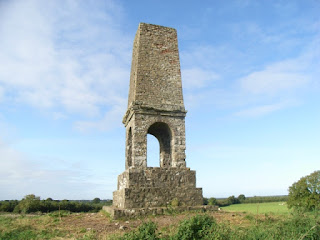
The Battery at Dangan Castle-
This was a toy fort, built to entertain Garrett Wesley, who was born in 1735- the father of Arthur Wesley, Duke of Wellington, who defeated Napoleon at Waterloo.
A visitor to Dangan in 1748 described the grounds at Dangan as having a garden of 600 Irish acres, and a gravel walk to a 26 acre man-made lake, which had several ships- one a complete man of war. Garrett was her godson, who played there.
(Diary of Mrs. Pendarves/later Mrs. Delaney)
Another visitor in 1752, Richard Pocoke, described the lake with an island fort and boats. On a hill near the Dangan house were a temple, and the hills around had obelisks and pillars.

The obelisk at Dangan
http://www.meathheritage.com/index.php/archives/item/me01788-dangan-battery
Thursday, August 27, 2020
Sweeneys- What is a Scottish Gallowglass??
Margaret Sweeney was born about 1805, presumably in County Meath, Ireland.
She married Richard Allen in Summerhill, Meath, on the 10th of July, 1825. They had 10 children, most of whom came to America, and most of whom settled in Jerseyville. She was my 2nd great grandmother.
I decided to look into the Sweeney's in Meath. First- a name search and a surprise! The name "Sweeney" comes from the Scottish galloglasses. What in the world is a galloglass? Sounds ominous! Indeed, it was!
This term derives from the "Galloglaich" who were an elite class of warriors of Norse and Scottish origin, who were hired as mercenaries by the Irish Kings to fight the English (they also fought for Robert Bruce in Scotland.) They were an aristocratic infantry, wearing heavy armor, and were much in demand as warriors. They were known for their skill with a broad sword or claymore, and a two handed axe. They wore mail, and an iron helmet. Each warrior was accompanied by two young squires who carried their spears and provisions.
 |
| 1521 drawing by Albrecht Durer (Wikipedia Commons) |
Many settled in Ireland after losing their lands in Scotland after they fought for the losing side in the wars of Scottish Independence. In return for their service, the Irish nobility granted them lands, and paid them an annual tribute of cattle and grain. The warriors fought in units of about 100 men.
Queen Elizabeth I so feared this group that in 1571 she had 700 of them executed after the first of the Desmonde (Fitzgerald) rebellions in Ireland.

The first and most famous Gallowglass families was the MacSweeneys.
 |
| An Irish Chieftan- 1581 John Derricke |
 |
| MacSweeney chief at dinner being entertained by a bard and a harper by John Derricke 1581 |
http://www.irishorigenes.com/content/gallowglass-do-you-belong-warrior-clan
The World of the Galloglass: Kings, Warlords, and Warriors in Ireland and Scotland 1200-1600 by Sean Duffy
The Twilight Lords: Elizabeth I and the First Irish Holocaust
By Richard BerlethMargaret Sweeny's relatives- Catharine Sweeney Fitzsimons
Catharine Sweeney
Catharine "Kitty" Sweeney married Andrew Fitzsimons in February, 1819, at the church in Dangan.
Andrew leased 12 acres of land in Clonmahon - a townland about 2 1/2 miles south of Dangan. Clonmahon was just outside of the village of Summerhill. His landlord was the Honorable Hercules Rowley- the owner of Summerhill Demesne. Unlike the ruins at Dangan, Summerhill house was a magnificent structure- one of the finest country estates in all of Ireland.

A visit to Margaret's sister Catharine and the Fitzsimon's cousins would have likely meant an exciting visit to the village of Summerhill, which sat in the shadow of the great house and estate at Summerhill.
The children of Catharine Sweeney and Andrew Fitzsimons were:
1-Christian baptized December 1819- sponsors Ratican and Gallaher
2-Catharine baptized February 1824- sponsors Michael Dunn and Alicia ?
3-Mary baptized May 1826- sponsors Pat Keeman and Mary Blake
4-Edward baptized February 1828- sponsors John Duff and Margaret Kennan
5-Margaret baptized April 1833- sponsors Richard Allen and Margaret White
6-James baptized February 1837- sponsors White and Kiernan
Catharine "Kitty" Sweeney married Andrew Fitzsimons in February, 1819, at the church in Dangan.
 |
| Ireland, Select Catholic Marriage Registers, Meath, Summerhill, 1812-1854, p. 9 |
Andrew leased 12 acres of land in Clonmahon - a townland about 2 1/2 miles south of Dangan. Clonmahon was just outside of the village of Summerhill. His landlord was the Honorable Hercules Rowley- the owner of Summerhill Demesne. Unlike the ruins at Dangan, Summerhill house was a magnificent structure- one of the finest country estates in all of Ireland.

 |
| Ireland, Griffiths Valuation 1847-1864, Meath, Laracor p 3 |
 |
| Clonmahon (top left), the Village of Summerhill, and the Summerhill Demesne- Ireland Ordnance Survey 1824-1846 p 44 |
A visit to Margaret's sister Catharine and the Fitzsimon's cousins would have likely meant an exciting visit to the village of Summerhill, which sat in the shadow of the great house and estate at Summerhill.
The children of Catharine Sweeney and Andrew Fitzsimons were:
1-Christian baptized December 1819- sponsors Ratican and Gallaher
2-Catharine baptized February 1824- sponsors Michael Dunn and Alicia ?
3-Mary baptized May 1826- sponsors Pat Keeman and Mary Blake
4-Edward baptized February 1828- sponsors John Duff and Margaret Kennan
5-Margaret baptized April 1833- sponsors Richard Allen and Margaret White
6-James baptized February 1837- sponsors White and Kiernan
Monday, August 24, 2020
History: Why did our Ancestors Leave Ireland? Understanding the Famine
Why did our ancestors leave their homes in Ireland? This website gave me a better understanding of what they faced during the famine and their immigration to America.
Subscribe to:
Comments (Atom)