 |
The Lives of Tenant
Farmers
The Allens and their neighbors did not own the houses that
they lived in or the land on which they had
toiled for generations. They were tenant farmers. The Penal Laws had
taken most rights from Irish Catholics- in early times they could not vote, buy
land, hold office, possess weapons, or even, in the earliest days, attend
school or legally practice their religion. By 1778 Protestants owned 95% of the
land. The Penal laws remained in effect until 1829, with the act of Catholic
Emancipation. But the results were already entrenched in a society of wealthy
Protestant land owners and poor Catholic tenant farmers. Richard Allen and his
neighbors leased their land from a gentleman named Charles P. Leslie.
Neighbors
Great Umberstown was a small rural district with a dozen or
so family farms. In the 1901 census for we see remaining neighbors- the
Sweeneys, Dorans, Byrnes, Reillys, Mahons, Murrins and Corcorans. Many of these
names appeared as baptismal sponsors for the Allen children in earlier years.
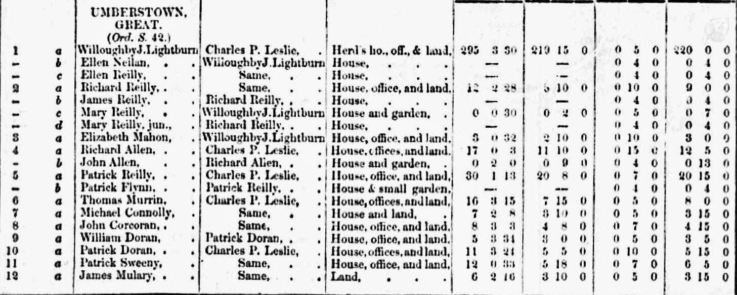
These farms appear in 1855 on Griffith’s Valuation showing their acreage and
location (number) on the valuation map. Richard Allen’s home was #4 on the map.
Patrick Reilly’s home (#5) was the largest in the area with 30 acres of land.
Patrick Sweeney (#11) had 20 acres, Thomas Murrin (#6) 16 acres, William Doran
(#9) 11 acres, John Corcoran (#8) 8 acres, Michael Connolly ((#7) 7 acres, and
James Mulary (#12) 6 acres. The amount of acreage tells an important story-although the land in Meath was fertile, supporting
a large family on less than 10 acres had to be very difficult.
Also shown in Great
Umberstown, next to Richard Allen’s farm, was Willoughby J. Lightburne (#1)
with 295 acres. Richard’s neighbor to the west was a Protestant landowner. Lightburne was a lawyer who
lived in Trim, his home there being “Harcourt Lodge.” His father Stafford Lightburne had been a
Protestant curate under Rev. Jonathan Swift (author of “Gulliver’s Travels)
when he was a minister in the Laracor Church of Ireland.[2] Lightburne would have hired farmers to
till his land and care for his grazing animals. This may have been an
additional source of income for the Allen family or their neighbors.
Figure 1- shows the map of Griffiths Valuation of 1855-
showing the plots of land of each tenant. Richard Allen was #4- note that the Allen farm borders the Dangan Estate in gray.The other plot numbers match the
names of the Great Umberstown neighbors above- Lightburn #1 is to the upper left of the Allen farm.)
Figure 2- Griffith's Valuation for Great Umberstown, with map location number, name of tenant, name of landowner, description of property, number of acres, tax value of land, tax value of house, and total taxes due (in pounds and shillings.)
[3]
Nearby family and
friends
At this point, we are unsure of who might have been in
Hugh’s extended family. But we do know that families of the time were large,
and that most people did not move far from their home farms (a fact that was
soon to change) so there is a good likelihood that relatives lived nearby. In
nearby Dangan, there were 24 residences including James Allen who lived on 5
acres, and Peter Allen lived on 3 acres. Likely friends (names appearing on
parish records as baptismal sponsors for the Allen family) were John McCann (19
acres) and Michael Rattigan (4 acres)- all tenants of Thomas Burrows, the owner
of the Dangan Estate.
There were also several Allen (and Sweeney) families in
nearby townships- close neighborhoods all within easy walking distance of Great
Umberstown. In Ballinrig were 8 residences, including a James Allen with 26
acres and a Rose Allen with 10 acres. Likely friends here were Walter Rattigan,
James, Thomas and Peter Byrne, and James Connolly. In Clondoogan were 45
residences, with John Allen (21 acres) Edward Allen (11 acres) and more Byrne,
Rattigan, and Reilly families. It is likely that Hugh grew up with numerous
aunts, uncles, and cousins.
You can search these records for further clues and see the
maps at:
(County meath, Barony Lower Moyfenragh, Union Trim, Parish Laracor- Great Umberstown is page 7 under Laracor Parish)
[1] London Illustrated Times (google pictures)
[2] Johnathan Swift: A Literary Reference to his Life and Works by Paul J. DeGategno, R. Jay Stubblefield
[3] Griffith's Valuation 1855 chart and map of Great Umberstown

